
The Foothills Trail, Winter Hike (February, 2020)
Table Rock State Park to Oconee State Park (West Bound)
The Foothills Trail is an approximately 76 mile trail in the Foothills of the Blue Ridge Mountains. The trail is mostly in South Carolina, which may come as a surprise to those of you who associate the Palmetto State with expansive beaches and, well, Palmetto trees. Having grown up in Upstate, South Carolina, though, I was no stranger to the Foothills as a child. While my family wasn’t particularly outdoorsy, we were athletic and the weekends that weren’t spent at cross country meets and volleyball tournaments we spent hiking up the nearby Table Rock.
When I graduated college and discovered the world of long distance hiking, The Foothills Trail immediately caught my eye. Its Eastern Terminus starts in my “backyard” State Park of Table Rock, then continues to traverse these short, but rugged, mountains. At the base of the Southern Appalachians, water is plentiful and so are the picturesque waterfalls and creeks. The trail eventually comes to hug Lake Jocassee, another footnote in my childhood memories. My grandparents lived on the neighboring Lake Keowee and trips to this area were a Sunday tradition. While both Jocassee and Keowee are famed for their emerald colored waters, Jocassee’s wilderness surroundings are in starch contrast to Keowee’s more developed shores. The trail’s western end hugs the Chattooga River and ends at South Carolina’s Oconee State Park.
This year, I had the pleasure of thru hiking the Foothills Trail on two separate occasions. The first was a somewhat spontaneous decision in February. A friend of mine who was planning to thru hike the PCT that summer wanted to traverse the Foothills Trail as final test to his gear choices. While I swore to never hike in the winter again, my previous summer had been spent recovering from Plantar Fasciitis and I was itching for a good backpacking trip. I packed up, convinced we would be hiking in snow despite the mild forecast. On President’s Day of 2020, Michael, Kimberly, and myself set off on this adventure.
Day 1- 16.3 miles
We spent the night at Michael’s parent’s house in Salem, SC, on Lake Keowee. They treated us to a carb-loaded dinner and warm beds before our trip. We woke while it was still dark and watched the sun rise over the lake while enjoying coffee and eggs. It was about a 45 minute ride to Table Rock State Park so we were able to hit the trail while it was still early. In no time, the trail begins to climb, turning away from the park’s namesake peak, instead ascending up the less-famous Pinnacle. The crowds thinned quickly. As we neared the summit of the Pinnacle we hit the most physically challenging part of the trail, climbing steeply on loose rock to the bald peak. The views from the Pinnacle showcase the Blue Ridge’s iconic layered mountains extending as far as you can see into the distance, but this view is an outlier in comparison to the views along the rest of the trail.
Further along we summited Sassafras Mountain, the highest peak in South Carolina. There is a new overlook platform at the summit, which can be reached via car, resulting in the most company we saw for the whole week. The 360 degree views and warm sunshine made this the ideal lunch spot. In no time, our gear was sprawled all over our corner of the overlook, prompting conversation with other visitors. I got to pet several dogs here, so it was a top notch experience.
Due to our early start we were able to accomplish some pretty solid mileage. At 16.3 we stopped at a primitive campsite to set up for the night. Michael started a fire even though the weather was mild. The cloudless skies continued into the night.
Day 2- 15.3 miles
We woke to a misty morning but the rain held off. The overall elevation change was mild in comparison to the day before. At this point, the trail shifts from climbing to peaks with vast views to dipping low and following creeks to waterfalls. I didn’t keep track of how many waterfalls were on or close to the trail, but it was at least a dozen. I was thankful for the lack of steep climbs and descents, but the trail was still narrow and rocky, and now slick with moisture.
It didn’t take long for us to realize how much trail maintenance goes into the Foothills Trail. At every river, creek, or even large puddle crossing, there were bridges built. While some were simple and aging foot bridges, many were more grand than you would expect to find in the wilderness. Suspension bridges and bridges with solid metal handrails welcomed us on a regular basis. We followed Laurel Creek through dense rhododendron thickets. Even in the grey winter weather, it felt as if we were in a jungle.
The trail eventually spits us out at Lake Jocassee after dancing up and down a feature called “Heartbreak Ridge”. The ridge was a series of steep accents and descents. While it certainly left us winded, it was milder than I was expecting and made easier by installed steps, another highlight of hiking such a well-maintained trail. The views of the lake were vast and serene. Dark grey mountains surrounded us with silver clouds swirling between the peaks, and the view was perfectly reflected in the glass-like emerald water. I braved the cold to soak my feet in Jocassee’s crisp waters during lunch. We soon crossed the Toxaway river on one of the grandest bridges along the trail. Michael informed me that the larger bridges are actually built off site, then helicoptered in to be installed. It amazes me how much effort goes into creating such a simple footpath, and I extend my gratitude to the organizations and volunteers that make it possible.
As we continued into the afternoon, the mist turned to rain. The last few miles were hiked in silence, the three of us spread out and going at our own pace. I arrived at camp after Michael, who was already in his tent for the night. I set up my 1 person shelter that had been a perfectly suitable tent for the entirety of the AT 2 years prior. As I huddled into the cramped space, attempting to do all my camp chores without getting wet, I had a realization. On the AT I slept in my tent far more often than in the shelters, but I still always camped near a shelter. Therefore, I was able to change my clothes, cook my dinner, and hang things out to dry under the roof of a shelter during rainstorms. It was a huge difference to manage all these tasks strictly in my tent. I quickly vowed to purchase a 2 person tent soon.
Day 3 – 12.3 miles
We woke up to a break in the rain but water continued to drip from the trees, and none of our gear had dried out in the least bit. Kimberly’s upbeat, giggling attitude kept us optimistic, though, as we wrung the rainwater out of our socks and shook out our tents. We had lower mileage planned for the day, so we took our time getting out of camp.
I immediately noticed how much lighter my pack was with another dinner and breakfast consumed. The soreness from the first day was beginning to fade and I was thrilled to notice that my feet were pain free. After a summer of plantar fasciitis, I had been nervous about my ability to complete this trail without further damage. We hiked among silver mist, over bridges and past waterfalls, and through more rhododendron thickets that formed long green tunnels. At this point, Michael and I began hitting our stride. I was impressed that I was able to keep up with him since he had been doing much more hiking and trail running in preparation. As she had warned us before, Kimberly cruised along at a slightly slower pace, stopping for more breaks and to take photos of curious looking fungi or plants. Michael and I would knock out a handful of miles, then enjoy a scenic view while we waited for her to catch up. He had his camera and a small tripod with him and was able to test out some fun techniques for shooting while hiking. As we sat on a large boulder on the shoulder of a deep and wide river, I realized how great this trail would be to hike in the summer. The swimming spots were endless, and the cool water would be so refreshing amid South Carolina’s brutal summer heat and humidity.
We passed the halfway point, climbed more freshly built stairs, and weaved along logging roads-turned-trail. The trail shifted from rhododendron and mountain laurel back to hardwood forest, a sea of grey and brown bare trees for miles. The lack of greenery made for more visibility and I saw our designated campsite before we reached it. It had benches! I was continually impressed with the accommodations built into this remote wilderness. For a brief moment, the clouds began to thin. Blue skies peaked through. In no time, I had all my gear pulled out and spread across the benches as if I was hosting a yardsale. Thankful for the thin canopy, I spent the next hour dedicating to rotating my gear and keeping it in patches of sunlight until everything was dry and warm. Kimberly and I spent the evening sharing some of our longer-distance hiking experiences with Michael, who was aspiring to thru hike the PCT that summer. We fell asleep early, shifting into the “rise and fall with the sun” sleeping schedule of living outdoors.
Day 4- 16.4 miles
If we didn’t have days like this, there wouldn’t be the fascination, enthusiasm, appreciation, and culture around backpacking. We woke to rain again, but this time it was cold. The temperatures dipped into the 30s. There was not a forecast for snow, but the trail gained elevation and I wasn’t too optimistic.
I really hate the cold. The cold and wet is even worse. I never have any trouble keeping my legs and feet warm, so I started the day in shorts and wet socks without a second thought. It’s my hands that always bother me- even in mild weather my fingers go numb gripping my trekking poles. I have tried a number of different fancy hiking gloves that cost an arm and a leg, but even then, my fingers lose all feeling. For this trip I decided to abandon any overpriced, brand-name glove and go with some big, pink, fluffly, fleece lined mittens from the gas station. To waterproof them, I wrapped them in plastic bread bags. My hands were useless, gripping anything besides my poles was impossible. There was no pulling out my phone, pushing my hair out of my face, or unwrapping snacks. But my hands were cozy and warm.
Sure enough, as we began to climb the next mountain the rain began to come down in frozen beads. We all begrudgingly watched as the sleet began to accumulate. It didn’t take long for the sleet to turn to snow and as we climbed higher, the snow accumulated into one inch, then two. Michael soon pulled ahead of me, while Kimberly stayed a good bit behind. We were left to our own devices to stay optimistic while our wet clothes started to freeze, and our noses turned red. Without the distraction of conversation, I grew pretty blue. I could see Michael’s footprints in the fresh snow and tried to match them to gain on him, but my short legs were no match for his long stride. I was attempting to entertain myself with a memory game as I descended to the gap that was to be our lunch spot. Here, the trail crossed a small backroad and a small parking lot, picnic table and pit toilet were provided. The snow was coming down in a thick blanket now and I squinted through it, trying to find Michael. He wasn’t at the table, and why would he be? If we tried to pull out our lunch in this weather, the tortillas would be soaked through with snow before we smother them in peanut butter. I glanced at the looming sihouette of the pit toilet and grimaced. Sure enough, Michael poked his head out. I quickly got over the aversion and joined him in the smelly, yet dry outhouse.
His gear was spread out on the cleanest surfaces available and he used the closed toilet as a seat while scarfing down some tuna. The smell was abrasive, but the ridiculousness of the situation had us grinning and giggling. He gawked at my still-bare legs. I was tempted to continue hiking in shorts since the continued movement was keeping me warm but my body temperature quickly declined on the break and I was soon eager to jump into some fleece-lined leggings. We continually peaked outside for Kimberly while working on our lunches. Eventually she arrived in the form of a black silhouette, bundled in all her waterproof layers and giggling audibly. I eagerly welcomed her to our dining area, more amused at the situation than disgusted at this point.
“Where is Suzie??” she asked Michael, red-faced and dripping the moment she stepped inside. Suzie is Michael’s mother, who lived nearby and had a relatively free schedule as she was recently retired. Apparently Kimberly had convinced herself that surely Michael would have no intention of continuing on the trail in this weather and would have used his Garmin to message his mom for a bail out. She had gotten over the last mountain by day dreaming of a warm car waiting for us, to carry us to a warm house with warm showers and beds. Then we could continue on when the skies cleared. Michael, who was using this trip as a test for his gear, mind, and body before the PCT had no such intentions but wanted to make sure the rest of the group was happy. I understood Kimberly’s perspective: on long trails you go into town all the time. If you can time up a hotel stay with a snowstorm and avoid the worse of it, all the better! But from Michaels perspective, we had set out to do this trip in 5 days with no town breaks, and he wanted to stick to that plan. “I can’t just call my mom to come pick me up when I am on the PCT,” he argued. As much as I hated the still-falling snow, I agreed with him and was happy to continue onward. After our lunch, we did just that.
The forest grew silent as the snow accumulated, absorbing all the sound around us. Rhododendron leaves curled in on themselves in the cold, and their branches hung low under the weight. The forest was beautiful. We had the trail mostly to ourselves since the second day, and felt even more secluded in this wintery landscape. I couldn’t help but to remove my fluffy-mittens-and-bread-bag ensemble to take some pictures.
The afternoon passed much like the morning. We were spread out on the trail and left to our own devices. I spent most of the time thinking about my gear. I was wearing a Frogg Togg rain jacket that had been with me for the whole AT. While it had seemed to prove itself against much more expensive alternative rain jackets, I realized it was probably at the end of its life. The material against my bag had been rubbed thin from my pack and cold, melted snow was slowly soaking through my shirt. I had a dry fleece with me but I was saving it for camp so I just continued onward, getting wetter and wetter. My leggings were growing damp as well and I wondered if rain pains would be a good investment. I had hiked the whole AT without them but most of the rain had been in the summer, when wet clothes weren’t as dangerous.
Eventually I caught up with Michael at the sign for Burrell’s Ford Campsite, our predetermined stopping point. This was our lowest point of elevation for the day and the falling snow turned back to rain. The ground was covered in a slush. It was a similar scene to our lunch location: a road crossing, a parking lot, and a pit toilet. Since this was a drive-in campground, we were optimistic for some luxuries. Trash cans, picnic tables, and if we were lucky, maybe even a picnic shelter for a break from the precipitation. We explored around the parking area for the campground and found nothing. After consulting our notes, we decided it might be further along trail and so we kept going. We were nearly a mile down trail before we decided we must have missed it and turned back. We returned to find Kimberly in the same parking area. She had also taken the time to explore the surrounding area and still we could find no campground. No picnic shelter or trash cans. Not even a flat spot to pitch a tent.
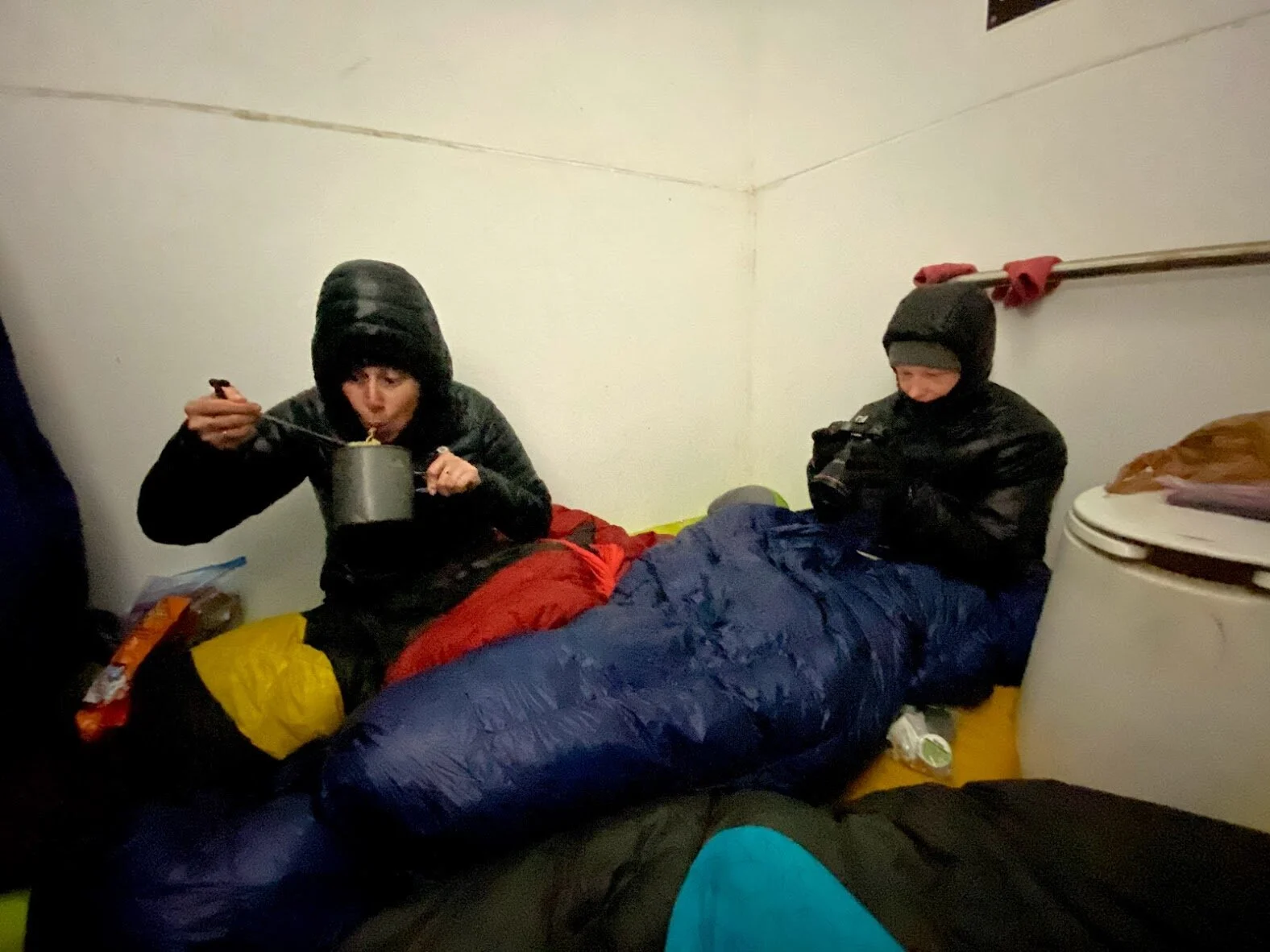
Michael had caved at some point in the afternoon and messaged his mom to ask for a pick up, or at least to be brought a hot meal. I knew it was mostly because he felt bad for keeping Kimberly out when she didn’t want to be, but it was a moot point. His mom’s car couldn’t navigate the snowy back roads. We huddled under the roof of the pit toilet trying to decide where to go that we might be able to pitch a tent. The next campground was several miles away, it was getting dark, and we were cold and tired. I had known it was an option from the beginning but finally introduced the idea: the pit toilet was dry, and flat. And it didn’t smell nearly as bad as the last one. It was just big enough for three sleeping pads. And we wouldn’t have to set up our tents, which would be sure to get soaked and freeze overnight.
In no time we had turned the spacious outhouse into our home. Our pads only just fit. We kept the toilet seat down and used it as a table to hold Michael’s camera and some other valuables. We kept our packs under the roof outside and only left the door slightly propped open. We were in a fit of giggles in no time. The scene was so ridiculous it was all we could do to stop laughing long enough to eat our dinners. It was a challenging day overall, and most of it was so miserable in the moment but it made for the best memory and story of the whole trip. With the three of us squeezed into the small space, our body heat warmed up the space quickly. I got the best night sleep of the whole trail in that small, cramped pit toilet.
Day 5- 15.9 miles
We woke to the very welcome site of clear skies, though the temperature was still below freezing. We were thankful for the ability to stretch out of our cramped quarters and spread out our frozen gear in the weak, winter sunlight while we ate breakfasts. Our food bags were nearly empty as this was our last day. I was proud of how accurately I packed food for the week. It is easy to over pack on food which just adds useless weight to carry.
My hiking socks were frozen solid (they literally bounced when I dropped them on the ground) but I was able to wear my dry sleeping socks since it was the last day on trail. My shoelaces were also frozen so I had to walk the first half mile in untied shoes until they thawed out enough to tie.
We could tell we had a beautiful day ahead of us as the sun slowly made its way higher into the sky. But the constant rhododendron thicket and dense woods around us kept us in cold shadows for much of the morning. I was in shorts again (sky’s out, thighs out!) but my fingers were stilled too cold to function and my pink gloves had eventually gotten to wet the day before, so they were of no use. I hiked with my hands in my armpits and trekking poles slung through my hip belt like a sward in a scabbard.
Before long, the trail led us to the banks of the Chattooga River. This is probably my favorite section of the whole trail. We passed several flat sandy banks and riverside campgrounds and I marveled again at how fun this would be to hike in the summer, when swimming would be an option. The sun reflected off the water turning the nearby trees golden. I stopped often to warm up in patches of sunlight, sending thanks into the universe.
We had lunch midday, and immediately spread our still-soaked gear in any patch of sunlight we could find. Everything was still a bit wet, and even though we were close to finishing and wouldn’t need a dry tent that night, it was still a relief to know our gear was dry. I finished the last of my food and marveled at how light my pack was without it.
After lunch, Michael and I pulled ahead of Kimberly. We entered into Oconee State Park lands and saw blazes for the Bartrum trail, another similarly distanced trail that runs through the area. I immediately began thinking about when I might be able to hike that trail. With the end in sight, I longed to not go home. I daydreamed about being able to leave work and every-day stresses behind for more time in the wilderness. A mile before the end, Michael and I stopped to wait for Kimberly. The sun was shining in full force now and we cherished the warmth. Kimberly arrived shortly and we hiked the last mile together, playing with the idea of quitting our jobs just so we could yo-yo (turn around and hike the whole thing back to where we started) this beautiful gem of a trail.
The trail ends at a kiosk in a secluded corner of Oconee State Park. The kiosk had information for the shorter trails in the area and a plaque that read “Western End of FHT”. We raced towards it with enthusiasm and had a silly photoshoot once we reached it. I was caught off guard by the sense of accomplishment I felt finishing the trail. In comparison to the Appalachian Trail, the FHT was short and easy. But it was still a challenge and I was proud of our group for finishing. I was thankful that I jumped through the hoops I needed to in order to get time off work to be out there.
Michael’s mom had dropped off his car at the State Park, so getting home was easy. We enjoyed the hospitality of his parents for one more night. Suzie’s homemade lasagna was a welcome meal after the week of ramen.
Summary
Scrolling through our photos I realized how unique this trail was. Even though it was so close to the southern portion of the AT, it was nothing like that more famed trail. The constant rhododendron and mountain laurel gave the entire trail a jungle-like feel despite the winter weather, and with nearly two dozen waterfalls and constant rivers and bridges, there was always something new and interesting around every corner. The elevation change was mild in comparison, making for easier hiking and the ability to make more miles. It’s a trail I would recommend to most backpackers. It would make for a great first long trail for anyone who is well prepared with gear. It’s solid training ground for the AT, as it presents similar challenges with weather. Water and campgrounds are plentiful so it would be easy to plan a trip along this trail at any pace, though keep in mind the more days you are out, the more food you have to carry. There are no resupply options along the trail, although caching food may be an option. It’s also unique enough to catch the eye of even the most experienced backpacker. Kimberly and I were both wow-ed by the trail, and I even returned for another thru hike that summer. And for those that don’t have the time for a week-long hike, this trail offers a number of great options for day hiking or a shorter weekend trip.
Thank you for reading this overview of my experience on the Foothills Trail. I hope you found it entertaining and informative. More information on the trail can be found at at the Foothills Trail Conservency website. An overview of my summer FHT thru hike can be found in a separate blog post. If you have further questions about my experience, I can be reached at nisbetth@gmail.com.
More photos from my adventure can be found on my Instagram.
Follow along with Michael and Kimberly’s adventures on the gram as well!

FHT Eastern Terminus at Table Rock State Park

Lake Jocasee, photo captured by Michael Hanson

One of the many rushing creeks and rivers along the FHT

The start of a snowy day
The pit toilet, turned shelter

Enjoying the sun along the shore of the Chattooga River

Michael, myself, and Kimberly at the Western Terminus of the FHT